
I have received many E-mail questions such as "What range does the V5 FM Mic TX give?". The distance a sun shines depends upon the eyes of the beholder. Range is the distance between transmitter and receiver whilst still receiving a useable signal. At 144MHz a range of 1,500,000,000 metres per watt is quite possible under ideal conditions. The V5 transmitter delivers 10mW (+10dBm) and could theoretically allow a range of 10,000,000 metres, under those same ideal conditions. Practical ideal conditions include at least 25dB of gain in the antenna system, a receiver sensitivity of 0.5uV (better than -123dBm) and no forms of unwanted attenuation in the signal path. So, let us look at a few factors that affect range. The items I will be considering here are:
If you look at your antenna specifications when you bought it from Lowe's, you will see that there is a quoted "gain". If they just state XXdB then you should ask what it means. A DeciBel is meaningless without a reference. Here are two commonly used reference levels for antennas:
dBi DeciBels referred to an "isotropic" antenna.
An Isotropic antenna is a theoretical antenna having zero size and radiates equally in ALL directions. The signal is therefore spread out all over and not quite as strong as:
dBd DeciBels referred to a "dipole" antenna.
It does not radiate in two directions therefore there is 2.4dB more signal radiated in the other directions. There is more signal radiated from a dipole than an isotropic antenna in the correct plane.
The moral of this is that if you want to sell antennas to gullible people, then quote the gain of the antenna referenced to the isotropic antenna, you get 2.4dB more gain that way. I have given you the formulas below for both dBd and dBi. If you wanted to sell loads of antennas then you could perhaps quote dBdl (dB referenced to the power radiated from a dummy load) and you could add 90dB to whatever antenna gain figures you have, why fool around with only 2.4dB?
Now let us work out the range of a hypothetical transmitter-receiver combination. Q. I want to know if I can get communications with the battery powered equipment I have. I therefore have three questions I want to answer:
To answer these questions we will need to know a lot of information about both the equipment and the lay of the land - a "Path Profile" must be drawn to enable us to see the signal path and evaluate the signal losses. You will be surprised how accurate you will be. You could alternatively buy an expensive program that would work it out for you. I don't have so many zeroes in the bank so I prefer to do it the hard (proper) way.
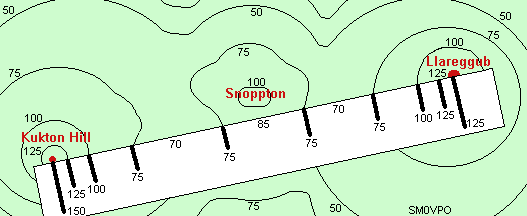
My example transmitter has an output power of 100mW and will be mounted on Kukton Hill and supported on a 30-metre tall mast. The transmitter uses an 8-element yagi having a gain of +8dB and is fed with 40 metres of UR76 coaxial cable having a loss of 4dB. The receiver is located on a small hillock at the North side of Llareggub and has a sensitivity of 1.0uV (-107dBm) for 20dB quieting (it's a brilliant receiver - built it myself!). The colinear antenna having a gain of 5dB is mounted on a 10-metre mast. 15 metres of UR76 coaxial cable, having a loss of 3dB, is used to couple the antenna to the receiver. Note that the cable losses quoted include losses of 0.3dB for each connector used. The distance between the Llareggub and Kukton Hill sites is exactly 40Km (26 miles). The transmitter frequency is 144.950MHz.
Before we can do anything at all we need know every condition that will affect the radio path. We know all the data about the TX and RX sites, but what is between them? Obviously we need more information. There are two sources of information we should use:
Take a good scale map showing height contours and lay a strip of paper on the route between Kukton Hill and Llareggub. Mark the paper with the height contours on the map as shown below. Here I have simplified the map considerably, but it shows clearly the two hills of Kukton Hill and Llareggub with Snoppton somwhere in the middle.
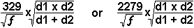
Next, calculate the Earth's "bulge" at several points between the path start and end points. You only need to plot, say, 5 points since they can be used twice, once from either end of the link. The formula for the bulge is:
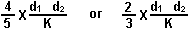
In the first formula I have used d1 and d2 = miles and in the second, d1 and d2 are in kilometers.
K is a constant where the actual diameter of the earth = 1 but this is not the case with wireless signals. The Earth is some 25% greater in diameter since the Earth also bends radio signals, effectively reducing the apparent bulge. K will normally be about 1.3 for VHF and UHF signals. Now you have made 5 calculations you can plot 9 points on graph paper and draw the Earth's bulge. It makes no difference what the vertical and horisontal scales are, just use anything that is convenient. I have chosen to use 1Km/division on the horizontal scale and 10m/division on the vertical scale. My scale starts at 70 metres height.
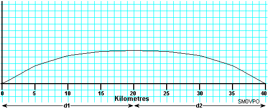
Now we must add the height information from the strip of the map we have marked from the map. You can lay the strip at 45 degrees so 0Km on both strip and graph are in contact. Connect the 40km mark of the strip to the 40km graph using a ruler and by keeping the ruler at the same angle you can mark all the points of the contour. The object is to get a graph like this showing a true profile of the contour of the Earth as the antennas see it.
As you can see, there IS a direct path, but is it a "free-space" path? For that we need to find out if the town of Snopton has any large buildings as the line of sight path goes rather close to the town. Snopton is another "sleepy hollow" village where geriatrics live and the tallest building is a 25-meter tall town-hall, as are most of the other buildings to the south of the city. This has to be added to the drawing.
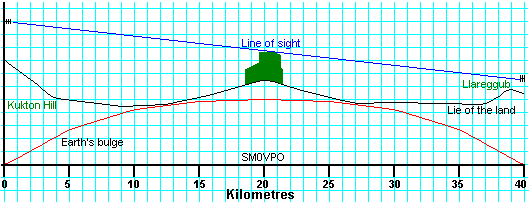
Now we see that by taking into account the Earth's bulge, there is something in the way of the signal. The signal is NOT simply a 0-metre thick line, it does in fact have a diameter. The diameter of the thickness of the path is given by the boundary of the 0.6 First Fresnel Zone. In practice it will look like a cigar-shaped area around the signal path, but as we see, we only need to know what it looks like at 20Kms. As it happens, at 144.950MHz our 0.6 First Fresnel Zone is only about 60 metres in diameter, but it is found by the formulas:
In the first formula "d1" and "d2" are in Km, f in megahertz and the result in metres. The second is in miles, megahertz and feet. So now we have a clear profile of the ground with the Fresnel boundary. Let us look at the 0.6 1st Fresnel boundary zone in a little more detail. Exactly what do we see if we were looking at the receiver antenna from the transmitter antenna?

"A" above is the clear space area and "B" is the ground and buildings area. 20 x Log(A/(A+B)) is the formula to work out the loss for an obstruction. In our case we have about 6dB of obstruction.
Now that we have worked out all the losses elsewhere we must work out our "free space" path losses, which are the only unknowns left. Use the formulas:
PL (dBd) = 28.1 + 20Log(d) + 20Log(f) or
PL (dBi) = 32.4 + 20Log(d) + 20Log(f)
where (d) is in kilometres and (f) is in Meggahertz, or
PL (dBd) = 32.27 + 20Log(d) + 20Log(f) or
PL (dBi) = 36.57 + 20Log(d) + 20Log(f)
where (d) is in miles and (f) is in Meggahertz. Putting our 40Km and 145MHz into the equasion we get a free-space path loss of only 109dB.
Now we are in a position to do our sums. Here I have two columns, one with the losses and the other with the gains. Since a dB is meaningless without a point of reference I have started the reference with the transmitter power of +20dBm (100mW). Now we can just add the gains and losses:
| Parameter | Gains | Losses |
|---|---|---|
| TX power | +20dBm | - |
| TX Ant gain | +8dB | - |
| RX Ant gain | +5dB | - |
| TX feeder loss (including connectors) | - | -4dB |
| RX feeder loss (including connectors) | - | -3dB |
| Obstruction loss (Snopton town) | - | -6dB |
| Path loss (free space - 40km @ 145MHz) | - | -109dB |
| Total gains and losses | +33dBm | -122dB |
Adding these two total figures together we get a final signal level of -89dBm, but our receiver sensitivity is -107dBm. We therefore have a signal path with +18dB to spare. If we wanted, we could reduce the transmitter power to get a 20dB quieting (12dB SINAD) signal of -107dBm and reduce the TX power by 18dB to -8dBm (or about 2mW). By the way, the V5 FM microphone TX gives out +10dBm so it IS possible to get 40km from it, IF you have the right receiver, antennas, masts, feeders etc.
From this exercise we have answered our basic questions posed at the beginning of the article:
The fade margin we would need is very small, but If you were planning a 30GHz link then rain would attenuate the signal by typically 20dB. Please note that I have not bothered to calculate the exact figures in the above examples since I am trying to show you the method. Should you see any glaring mistakes then please feel free to correct me. I do make errrorss when rushing to get these pages on the web, but I am trying my best to get it right AND keep it all simple. One last point, this is only just enough to get you started. If you wish to learn more about the subject then a visit to your local library or university bookshop could be in order.
Best regards from Harry, SM0VPO